Atlas login
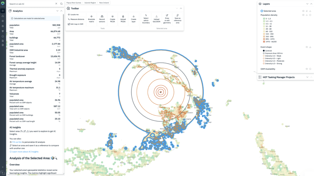
This real-time risk analysis is critical for directing emergency resources where they are needed most. Integrating satellite imagery, sensor data, and field reports allows us to quickly generate accurate hazard maps and assess vulnerabilities.
Who Is It for?
This webinar is for you if you work with the following topics:
Resource Allocation
People Support
Medical Assistance
Disaster Response
Climate Monitoring
People Displacement
Natural Disaster Risk Management
Map Improvements
What we will demonstrate?
We will show how risk analysis works for hazards using GIS analysis.
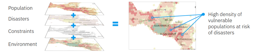
consider 3 examples from real life:
We will also show examples of analysis based on the cases you propose and answer all your questions in real time.
You can watch the recording of our previous webinar ‘Answering ‘Where’: How to сhoose the right place for anything?‘ on our YouTube channel.
Why we do this?
We have an expertise in GIS for disaster management with extensive collaboration across humanitarian, governmental, and business sectors.

Our actions
Kontur automated MapAction’s GIS data collection and validation processes, streamlining the creation of disaster response maps.
Results that matter
This increased operational speed, saved volunteer time, and improved overall efficiency during emergencies.
Our actions
Kontur enhanced the OpenAerialMap platform with a user-centric redesign and new features, including an Orthophoto Map mosaic layer and streamlined & fixed image uploads.
Results that matter
These improvements made the platform more intuitive and efficient, enabling faster map creation for lifesaving missions.

Our actions
Kontur developed Event Brief to automate disaster reporting, using data from PDC and its partners.
Results that matter
This innovation ensures rapid, accurate information delivery, empowering swift and effective decision-making during critical situations.

Our actions
Kontur created a custom geo-solution for GlobalGiving, enabling real-time disaster scoring and notifications.
Results that matter
The platform streamlines disaster assessment and delivers precise insights on its impact, helping the organization connect donors with critical grassroots projects faster and more effectively.
Other partners:


Join the webinar
Fill out the form and confirm your email address to receive a link to participate in the webinar and subscribe to the reminder about the upcoming event.
Don’t miss this chance to discover new opportunities for your challenges!